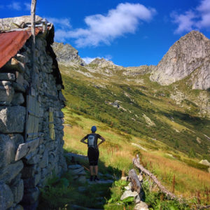
The hike from Val Merdarola to Valle dell’Oro, through the Bocchetta di Medaccio, is a long and savage trail that goes through few popular areas and sometimes few signed. It’s also possible to follow the trail in the opposite direction. Shortly: Elevation gain: 1136 m. Hiking time: about 8 hours Difficulty: EE Max elevation: Bocchetta…
Category: Val Masino
Hiking Val Masino. Hiking time, difficulty, elevation gain and tips.
Hike to Passo dell’Oro – Valle dell’Oro
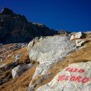
Passo dell’Oro, 2574 m. lies at the extremity of the Valle dell’Oro between the Val Masino and the Val Codera. Shortly: Elevation gain: 1400 m. from Bagni di Masino or 475 m. from Rifugio Omio Hiking time: 4 hours from Bagni di Masino – 1,30 hours from Rifugio Omio Difficulty: E Max elevation: 2574 m.…
Hike Val Qualido – Valle di Zocca, through the Passo Averta
The hike from Val Qualido to Valle di Zocca, through the Passo Averta towards the Rifugio Allievi – Bonacossa, is very long and panoramic. Only for experts, accessible during the summer. Shortly: Elevation gain: 1464 m. Hiking time: 8 – 10 h Difficulty: EEA (sections with chain) Max elevation: Passo Averta 2540 m. Trail: marked…
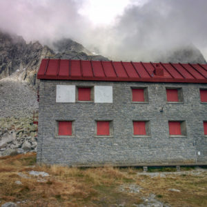
Hike Rifugio Omio to Rifugio Gianetti, through Passo del Barbacan
Bagni di Masino → Rifugio Omio → Passo del Barbacan → Rifugio Gianetti → Bagni di Masino. Amazing and long hike, accessible also in the opposite direction. Shortly: Elevation gain: 1426 m. Hiking time: 8 – 10 hours Difficulty: EEA (sections with chain) Max elevation: Passo del Barbacan 2598 m. Trail: n° 21 marked with…
Hike Pizzo Bello, start from Preda Rossa
The hike to the Pizzo Bello, starting from Preda Rossa, offers fantastic views in all directions and the trail is well marked.This post is about the hike to the Pizzo Bello with start from Preda Rossa in Val Masino even if the summit is often reached starting from Rifugio Marinella in Prato Maslino, climbing up…
Hike Pizzo dell’Oro Southern – Val Masino
The hike to Pizzo dell’Oro Southern is at the limit between hiking and easy mountaineering with difficult until II grade. Only for expert. Shortly: Elevation gain: 1595 m. Hiking time: 5 hours Difficulty: EE (with really steep sections) + short sections of II grade (exposed) Max elevation: 2695 m. Trail: without number but with many…
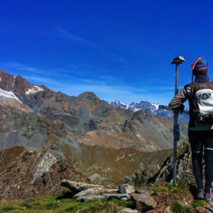
Hike to Passo Ligoncio – Valle dell’Oro
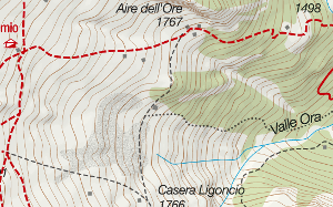
The Passo Ligoncio, 2575 m. is located in hight Valle dell’Oro, between Val Masino and Val Codera. Shortly: Elevation gain: 1400 m. from Bagni di Masino or 475 m. from Rifugio Omio Hiking time: 4 h. starting from Bagni di Masino – 1,30 h. from Rifugio Omio Difficulty: E Max Elevation: 2575 m. Trail: without…
Hike Bivacco Molteni Valsecchi in Valle del Ferro – Val Masino
The Bivacco Molteni Valsecchi is located in the Valle del Ferro, a side valley of Val di Mello, elevation 2515 m. Even if the trail is not well marked the hike is very beautiful, in a pure and savage valley. Notable elevation gain. Shortly: Elevation gain: 1500 m. Hiking time: 4-5 hours Difficulty: EE Elevation…
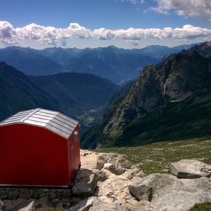
Hike Rifugio Allievi in Val di Zocca – Val Masino
Rifugio Allievi (or Rifugio Allievi Bonacossa) is located in Val di Zocca, one side of the famous Val di Mello.The hike is very long but you have the opportunity to visit awesome places. Shortly: Elevation gain: 1360 m. Hiking time: 4 hours Difficulty: Easy/Moderate Elevation: 2385 m. Trail: without number but well marked by white…
Hike Rifugio Alpe Granda. Starting from the place of Valbione
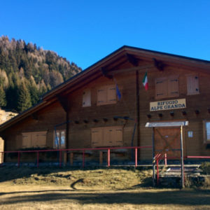
Rifugio Alpe Granda is located in the homonymous mountain pasture over Ardenno, elevation 1680 m. You can reach the refuge starting from different places. This hike follows the trail which starts from Valbione place, in Val Masino. Shortly: Elevation gain: 528 m. Hiking time: 2 hours Difficulty: Easy Elevation: 1680 m. Trail: n° 19 Warning:Trekking…