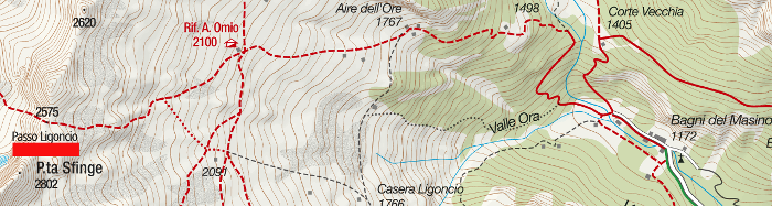
The Passo Ligoncio, 2575 m. is located in hight Valle dell’Oro, between Val Masino and Val Codera.
Shortly:
- Elevation gain: 1400 m. from Bagni di Masino or 475 m. from Rifugio Omio
- Hiking time: 4 h. starting from Bagni di Masino – 1,30 h. from Rifugio Omio
- Difficulty: E
- Max Elevation: 2575 m.
- Trail: without number but well marked by white and red signs
Warning:
Trekking is an inherently dangerous activity. The hike here described can be a dangerous activity if faced without the right preparation. Mountain conditions can be very dramatically from one season to the next. Always seek local advice on current conditions, check the weather and don’t take anything for granted.
The author accepts no liability whatsoever for any loss, injury or inconvenience resulting from the use of this blog.
Starting point:
Bagni di Masino, 1172 m. Drive through Val Masino to San Martino and then continue on the left until the end of the road. The parking area is limited and the lot fills early.
Trail description:
From Bagni di Masino parking area reach the Rifugio Omio as describe in this itinerary, about 2 h. Easy trail and well marked.
From the Rifugio Omio find the path that continues westward, at the beginning little evident better shortly after.
Follow the red and white signs reaching a steep valley with drystone walls and climb zigzagging the path. The trail continues climbing to an evident granite slab and a short and easy section with a chain.
The final stretch of the trail is steep but very short.
Descent:
Along the same trail.
Other:
For information on opening times visit the Rifugio website
Hike: hike to Rifugio Omio
Recommended Map: Kompass n. 92
More hiking Val Masino
Sere