The hike up to Croce GAM (Cima GAM) on the Costiera dei Cech is a not easy and quite long climb. The hike is an opportunity to visit places rarely visited and characteristic. Only for experts of mountain and experts of this specific area.
Shortly:
- Elevation gain: 1500 m.
- Hiking time: 5 hours
- Difficulty: EE (path with some very steep sections)
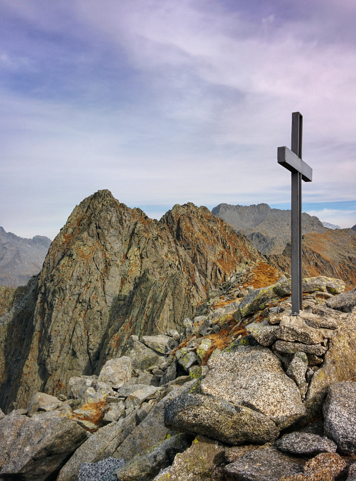
- Elevation: 2585 m.
- Trail: n° 23 until Alpe Visogno, then only footprints, a few trail signs and ducks.
Warning:
Trekking is an inherently dangerous activity. The hike here described can be a dangerous activity if faced without the right preparation. Mountain conditions can be very dramatically from one season to the next. Always seek local advice on current conditions, check the weather and don’t take anything for granted.
The author accepts no liability whatsoever for any loss, injury or inconvenience resulting from the use of this blog.
Starting point:
Poira of Civo, at the end of the road, where there is a parking area. From Morbegno follow the signs road to Dazio then Serone. At the crossroads of Chempo’s village, turn left, after a few meters you’ll see on the right the B&B Costiera dei Cech ;-), continue straight (3 km) until the end of the road. Big parking area.
Trail description:
The trailhead lies few meters before the football field. Follow the signs to Bivacco Bottani.
The trail climbs steeply up to cross a dirt road (firebreak). 1 h.
Continue climbing the steep trail leading to big and sunny meadows of Pre Soccio (1653 m.). 40 minutes.
The trail continues climbing and losing among the grass, in this part the trail is not very clear, so, point up, on the left, to where the meadows finishes and you find the trail again.
The trail reaches Alpe Visogno (2000 m.) in 1 hour.
From here, on the left, you can recognize the 3 Cornini, that arises from an old moraine of a glacier.
The trail is not marked, but I suggest climbing yet one hundred or so meters towards the direction of Bivacco Bottani, that you see in the upper right part, and then cross horizontally the valley until you’ll locate a ledge leading easily to the thread of the moraine.
Continue along the moraine until a steep grassy slope. Follow it on the left climbing to a grassy path very exposed.
After 10 minutes you’ll reach a large flat area on the right, that you’ll leave to continue until an area with boulders and marked with signs and ducks.
Now it’s very important not to mistake, trying easier paths to reach the summit.
Continue climbing diagonally to the right until a rocky spur with a trail sign. Climb to the steep rocky gully until you’ll reach, on the right, a mountain pass (it’s not much visible in up and down direction), cross slightly the mountain pass and climb another steep gully with rock and grass.
Continue climbing to a short stretch very steep where, depending on the path you choose, you may need to use your hands.
The final section is less steep. With a zig-zag path you’ll reach the ridge and continuing on the left you’ll reach the Cima GAM, 2585 m.
Spectacular views! 5 h.
Descent:
Along the same trail. Be careful in the steepest section.
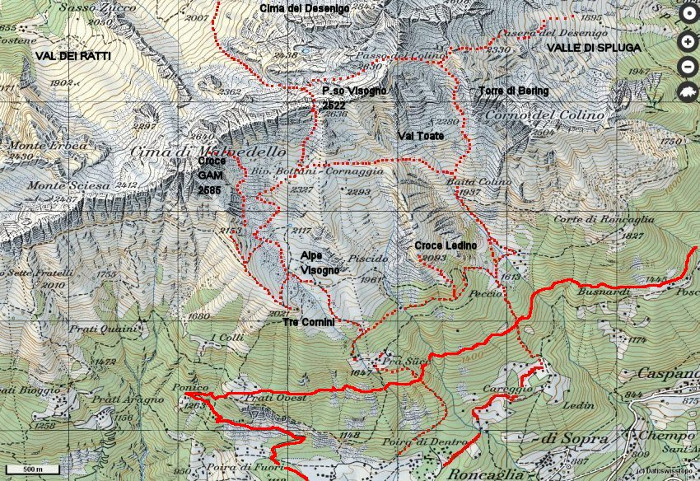
©Paesi di Valtellina – Map Swisstopo.
Connected trail:
It’s possible split this long climb staying at Bivacco Bottani.
During the descent it’s possible to reach the 3 Cornini, located on the edge of the moraine.
Story:
the Croce (cruise) GAM was erected in 1982. The world GAM is the abbreviation of GRUPPO (Group) AQUILE (Eagles) di MORBEGNO.
Other:
Recommended Map: Kompass n°92 but neither the mountaintop or the altitude are marked. It’s located between Cima di Malvedello and Monte Sciesa.
More hiking Costiera dei Cech
Sere